Home
The ESA – SEOM funded CIRCAS (ConsIstent Retrieval of Cloud Aerosol Surface) project aim at providing a set of atmospheric (cloud and aerosol) and surface (albedo) products derived from S3A/SLSTR observations retrieved using the same radiative transfer physics and assumptions. The retrieval is based on the CISAR (Combined Inversion of Surface and Atmosphere pRoperties) algorithm. CISAR is an advanced mathematical method developed by Rayference for the joint retrieval of surface reflectance and atmospheric (cloud and aerosols) properties from observations acquired by space-based imagers.
The CISAR algorithm relies on the FASTRE radiative transfer model that describes surface reflectance and atmospheric absorption/scattering processes. The lowest level represents the surface. The lower layer hosts the aerosols. Molecular scattering and absorption are also taking place in that layer which is radiatively coupled with the surface for both the single and the multiple scattering. The upper layer is only subject to molecular absorption.
The inversion of the FASTRE model within the CISAR algorithm against satellite observations provides accurate estimates of the surface reflectance field, aerosol or cloud optical thickness and single scattering properties in each processed spectral band. An estimate of the retrieval uncertainty is also provided.
As the proposed method retrieved both cloud and aerosol properties with the same retrieval algorithm, no cloud mask is needed to perform the retrieval. Additionally, the same algorithm can be applied over any type of surfaces, including dark or bright surfaces or water bodies.
News
08/11/2022 Final Review Meeting
The CIRCAS Final review meeting took place online through Microsoft Teams. The positive impact of the improved calibration of SLSTR has been discussed during the presentation of the validation results. The extensive validation report prepared by Brockmann Consult with the support of Rayference showed encouraging results achieved by this ambitious and innovative project. The work performed within CIRCAS will be extended within other ESA project such as Aerosol-CCI+.
22/09/2020 Acceptance Review Meeting
The CIRCAS acceptance review meeting took place online through WebEx. The objective of the meeting was to review the first validation results of the CISAR retrieval of aerosols and clouds properties, surface reflectance and solar downward fluxes.
08/05/2020 CIRCAS presented at EGU 2020
CIRCAS intermediate results on the consistent retrieval of cloud and aerosol single scattering properties and surface reflectance have been presented at the EGU 2020 (virtual meeting due to COVID). The presentation can be found here.
11/12/2019 Correction of the SLSTR solar band calibration
Rayference has been working on the verification and correction of the S3A/SLSTR solar bands. This activity has been reported in web story of the Eradiate project entitled "Estimating the accuracy of 1D radiative transfer models over the Libya-4 site". Following this study, the S3A/SLSTR Level 1b TOA BRF corrections recommended by Rayference, displayed in the following table,
| Bands | S1 | S2 | S3 | S5 | S6 |
| S3A/SLSTR NADIR VIEW | |||||
| Correction | 0.95 | — | — | 1.10 | 1.10 |
| S3A/SLSTR OBLIQUE VIEW | |||||
| Correction | 0.92 | 0.93 | 0.93 | — | — |
will be used by the CIRCAS project. These calibration correction factors should multiply the delivered top-of-atmosphere bidirectional reflectance factor (TOA BRF) values. The complete analysis is presented in a dedicated report.
09/05/2019 CIRCAS presented at The Fifth Sentinel-3 Validation Team Meeting
The CIRCAS project has been presented at the 5th Sentinel-3 Validation Team Meeting. The presentation can be found on the event website website.
06/12/2018 Mid-Term Review
The CIRCAS mid-term review took place in Hamburg. The objective of the meeting was to review the CIRCAS progress during the first year of the project.
11/01/2018 Science Review
The CIRCAS science review took place at Rayference premises located in Brussels. The objective of the meeting was to review the Requirement Baseline Document and the draft version of the ATBD.
29/09/2017 Kick-off meeting
The CIRCAS kick-off meeting took place at ESA-ECSAT (UK).
Results
Publication alert!
The development on the CISAR algorithm to extend the retrieval to cloud single scattering properties, initiated within the CIRCAS project and continued within the Aerosol-CCI+ ESA project, have been published on the Atmosphere MDPI journal (Luffarelli et al., 2022). The proposed approach aims at filling this gap and deepening the understanding of aerosol properties in cloudy environments. The new CISAR version is applied to Sentinel-3A/SLSTR observations and evaluated against different satellite products and ground measurements. The spatial coverage is greatly improved with respect to algorithms processing only pixels flagged as clear sky by the SLSTR cloud mask. The continuous retrieval of aerosol properties without any safety zone around clouds opens new possibilities for studying aerosol properties in cloudy environments.
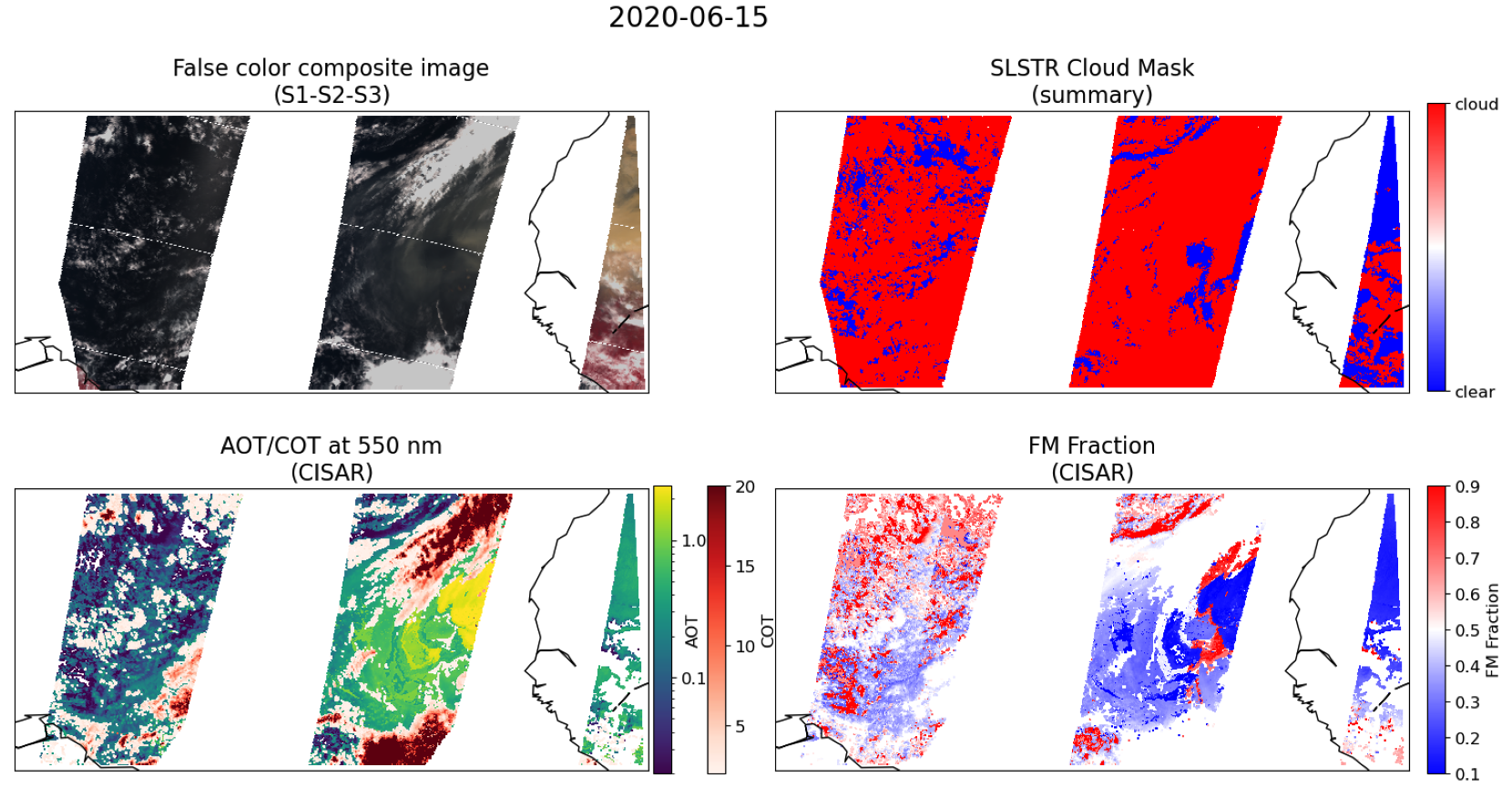
2020 Godzilla Dust Storm
In June 2020, a dust plume originating from Sahara was transported towards the Caribbean islands, traveling more than 8000 km and peaking between 14 and 20 June. This dust storm was so extreme that it has been named Godzilla. This extraordinary dust plume, nearly as big as the continental United States, weighed almost 24 million tons. Godzilla was surprising not only in terms of size and weight but also in terms of its trigger.
Most of the dust storm is unfortunately misclassified as cloud from the SLSTR summary cloud flag (see Figure below). Aerosol retrieval algorithms only inverting clear-sky observations would therefore completely miss such an exceptional event. Conversely, the CISAR algorithm, not relying on an external cloud mask, performs the retrieval over all SLSTR observations regardless of the cloud mask classification. The Figure below shows the false-color composite obtained from SLSTR bands S1, S2, and S3, the SLSTR summary cloud flag, the combined AOT and COT retrieval at 0.55 μm with the CISAR algorithm, and the FM fraction associated with the AOT retrieval. It can be seen that most of the dust storm, partially visible in the false-color composite, is flagged as cloud. In particular, about 85% of SLSTR observations are flagged as cloud; with a retrieval algorithm only inverting clear-sky observations, the aerosol retrieval would be performed only on the remaining 15% of the pixels. CISAR, however, retrieves valid AOT (i.e., greater than 0) over 35% of all SLSTR observations, greatly improving the spatial coverage of the AOT product.
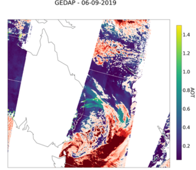
2019 Australian Fires
In the framework of the ESA Aerosol Climate Change Initiative (Aerosol-CCI+) project, the CISAR algorithm, extended to the retrieval of clouds within the CIRCAS project, has been applied to SLSTR / Sentinel-3A observations acquired in the visible and near-infrared bands. On 6th September 2019 CNN reported over 100 wildfires over Australia, in the states of Queensland and New South Wales. CISAR retrieval during this extreme event shows that CISAR correctly discriminates between high aerosol loads and clouds, with continuity between cloudy and cloud free sky.
A webstory on the results obtained with the CISAR algorithm from SLSTR observations during the Australian fire season in 2019 has been published by ESA.
Correction of the SLSTR solar band calibration
Rayference has been working on the verification and correction of the S3A/SLSTR solar bands. This activity has been reported in web story of the Eradiate project entitled "Estimating the accuracy of 1D radiative transfer models over the Libya-4 site". Following this study, the S3A/SLSTR Level 1b TOA BRF corrections recommended by Rayference, displayed in the following table,
| Bands | S1 | S2 | S3 | S5 | S6 |
| S3A/SLSTR NADIR VIEW | |||||
| Correction | 0.95 | — | — | 1.10 | 1.10 |
| S3A/SLSTR OBLIQUE VIEW | |||||
| Correction | 0.92 | 0.93 | 0.93 | — | — |
will be used by the CIRCAS project. These calibration correction factors should multiply the delivered top-of-atmosphere bidirectional reflectance factor (TOA BRF) values. The complete analysis is presented in a dedicated report.
Team
The CIRCAS project team includes Rayference as prime contractor and Brockmann Consult as partner.
 Rayference
Rayference is an Earth Observation research and development company providing technical and scientific expertise in 1D and 3D radiative transfer, both in the atmosphere and at the surface, and inverse modelling. This expertise is applied in areas such as retrieval of aerosol and surface properties from space observations, vicarious calibration, fundamental and thematic climate data record generation or sensitivity analyses for the preparation of new space missions and associated services.
Rayference project activities include:- Project management
- ATBD preparation
- Adaptation of the CISAR algorithm for the processing of SLSTR dual view observation
- Improvement of the CISAR algorithm for the consitent retrieval of surface, cloud and aerosol properties
 Brockmann Consult
Brockmann Consult is a private commercial company (SME) founded in 1999 in Hamburg as private business and turned into GmbH in 2002. BC offers services for the management of environmental data in particular from Earth Observation. The company comprises two complementary branches: The Environmental Informatics Department and the Geo-Information Services Department.
The Environmental Informatics Department develops custom-made software solutions for environmental data. The cornerstone of the department’s activities is system development for Earth Observation data processing systems and data analysis software. Important EO software products include the Hadoop-based Calvalus System for massive parallel processing of big data, the ESA Climate Change Initiative Toolbox, and SNAP, the Sentinel Application Platform. The staff members of the department are internationally recognized experts combining professional software engineering with natural sciences expertise. They advise customers on the design and implementation of processing systems and provide turn-key system solutions.
Brockmann Consult project activities include:Contributions
The CIRCAS project has been presented in the following conferences and workshops:
- Marta Luffarelli, Yves Govaerts, Carsten Brockmann, Grit Kirches, Thomas Storm, Simon Pinnock, Towards a consistent retrieval of cloud/aerosol single scattering properties and surface reflectance, The Fifth Sentinel-3 Validation Team Meeting 2019, 7-9 May 2019 - ESA/ESRIN, Frascati, Italy
- Luffarelli M. , Govaerts Y., Pinat E., Kirches G., Storm T., Pinnock S., Towards a consistent retrieval of cloud/aerosol single scattering properties and surface reflectance, Living Planet Symposium 2019, A1.05: Aerosols and Clouds, 13-17 May 2019, Milan, Italy, April 2019
- Marta Luffarelli, Yves Govaerts and Sotiris Sotiriadis, Towards a consistent retrieval of cloud/aerosol single scattering properties and surface reflectance , 7th AeroSAT workshop September 23 – 28, 2019, BSC, Barcelona, Spain
- Marta Luffarelli, Yves Govaerts, Sotiris Sotiriadis, Carsten Brockmann, Grit Kirches, Thomas Storm, Simon Pinnock, Towards a consistent retrieval of cloud/aerosol single scattering properties and surface reflectance, EGU General Assembly 2020, 6 May 2020
- Marta Luffarelli, Yves Govaerts, Carsten Brockmann, Grit Kirches, Thomas Storm, Towards a consistent retrieval of cloud/aerosol single scattering properties and surface reflectance, The 6th Sentinel-3 Validation Team Meeting, 15 December 2020